Again in 2010 West Virginia was just a pass through state. In early October we stopped overnight in Martinsberg on the way from Maryland on our way to Virginia and exploring Skyline Drive looking for fall colors.
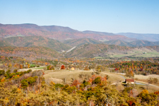
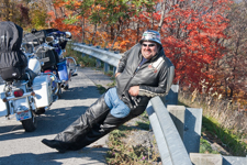
After basically giving up on finding any really nice fall color we escaped Virginia on Route 33 headed for Kentucky and camping with some friends. Here from the Germany Valley Overlook is by far the best color we had found. Another visitor to the overlook was hamming it up and asked me to take his picture so here it is guy.
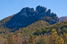
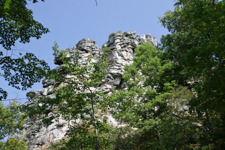
Along the way we stopped at Seneca Rocks State Park both for the restrooms and because our oldest comes here frequently for climbing. It is very interesting that you hear so often how we should live with nature like the Native Americans. The short answer is that we do. Archaeologists have discovered here repeated stays by tribal groups that fished out the river, hunted out the game, cut all the trees for firewood, and destroyed the soil with farming until they were forced to move on and allow the land to recover until a later generation would follow the same pattern. Seems the more things change the more they stay the same.
In 2009, West Virginia was just a pass through state returning from winter in the south to helping the doctors back in Columbus, Ohio with their Mercedes payments before heading back toward dad in Shreveport, Louisiana.
In September we started another tour through more of my old whitewater haunts. I had also signed up for a photography program at Twin Falls State Park and then we planned to meander in the southern Alleghenies. Due to luck and a need to mail the September estimated taxes we also discovered the Mullins Murals which I have split out to their own page.
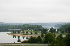
Our first stop was the Summersville Lake campground shown here. The Summersville Lake discharges to start the famous Gaully River whitewater area. Each fall releases are scheduled to lower the lake to winter pool and allow weekend kayak and raft runs. Summersville is also one of the few Corp of Engineers lakes not named after the closest town which was Gad. I'm sure you can imaging how Gad Dam
would be modified.
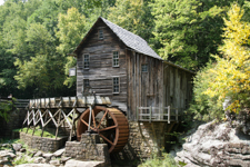

Above are a few pictures of Babcock State Park. The Babcock Mill is probably one of the most famous views of West Virgina. The mill still operates when there is enough water and the products are available in the gift shop.
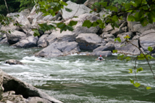
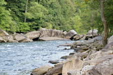
One of my major reasons for visiting West Virginia was to track down and thank the guys who helped me when I had a blackout running Lower Keeney here on the New River in 2004. The squirt boater shown here was one of those who pulled me out, performed CPR, and helped get me back across the river for extraction to Charleston General Hospital where I spent five days in ICU, five days in the ward, and another five months out of work. This is the short version of a story encompassing about a half dozen miracles with a lot of luck.
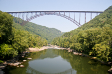
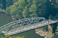
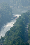
A little further down the New River which actually flows north is the end of the whitewater area near Fayetteville. The original Fayette Station bridge at the bottom of the gorge is still usable, however, taking the winding switchback road all the way down to the bottom of the gorge and back up the other side is an adventure even without pulling a semi trailer. The new Route 19 bridge was the highest and longest single span bridge when it was finished in 1977 and is essentially the West Virginia State Symbol. Bowing to popular pressure and trying to improve safety it now closes once a year for Bridge Day allowing parachute jumps to be made legally.
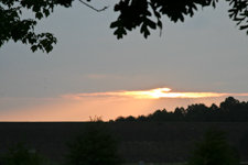
Finishing up West Virginia for 2007 is a sunset over Summersville Lake and a view of the namesake for Pinicale Rock State Park. I have spent a lot of time in West Virginia but that was mostly on the river and this was one of the few opportunities we have had to just relax and explore this interesting state.